-
Wählen Sie die Sprache der Website
-
 Deutsch
DE
Deutsch
DE
-
 English
EN
English
EN
-
 Français
FR
Français
FR
-
 Español
ES
Español
ES
-
 Italiano
IT
Italiano
IT
-
 Polski
PL
Polski
PL
-
 Português
PT
Português
PT
-
Land, in das versendet werden soll

-
Wählen Sie die Sprache der Website
-
Deutsch
DE
-
English
EN
-
Français
FR
-
Español
ES
-
Italiano
IT
-
Polski
PL
-
Português
PT
-
Land, in das versendet werden soll
-
Wählen Sie die Sprache der Website
-
Deutsch
DE
-
English
EN
-
Français
FR
-
Español
ES
-
Italiano
IT
-
Polski
PL
-
Português
PT
-
Land, in das versendet werden soll
-
Menue

-
Ränge

-
Brettspiele

-
Rollenspiel

-
Partyspiele

-
CG

-
Zubehör

-
Lego

-
Buecher

-
Comics


Herausgeber: Historic One
Cry Havoc Map The Welsh Castle

uplay.it Preis
Einzelhandelspreis
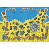
Herausgeber: Historic One
Cry Havoc Map The Fortified Village
uplay.it Preis
Einzelhandelspreis
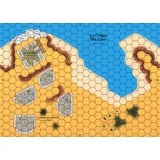
Herausgeber: Historic One
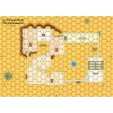
Cry Havoc Map The Caravanserai
uplay.it Preis
Einzelhandelspreis
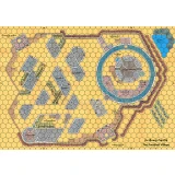
Herausgeber: Historic One
Cry Havoc Map The Saxon Harbour
uplay.it Preis
Einzelhandelspreis
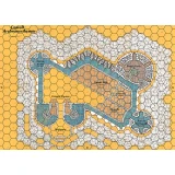
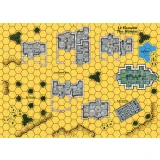
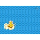
Herausgeber: Historic One
Cry Havoc Map The Welsh Castle
Karte, die eine Burg mit der typischen Architektur der Festungen zeigt, die König Edward I. von England zu Beginn des 14. Jahrhunderts zur Kontrolle v...
Herausgeber: Historic One
Cry Havoc Map The Fortified Village
Double map representing a circular castle and its village defended by a wooden palisade. The plan is inspired by the castle of Avalon in the Daup...
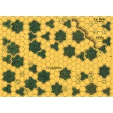
Herausgeber: Historic One
Cry Havoc Map The Hamlet
Map representing a village grouped around its church. The map meets the Cry Havoc standard, is printed in high definition (300 dpi) and on a strong...
Herausgeber: Historic One
Cry Havoc Map The Caravanserai
The map displays a courtyard surrounded by stables and an inn. A covered passage provides access to a small medina located higher up. The map meets...
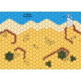
Herausgeber: Historic One
Cry Havoc Map The Beach
Karte, die eine Küste mit einem durch Deiche geschützten Strand zeigt. Die Karte entspricht dem Cry Havoc-Standard, ist in hoher Auflösung (300 dpi) g...
Herausgeber: Historic One
Cry Havoc Map The Cove
Map showing a coast with a cove dominated by a watchtower and some dwellings. The map meets the Cry Havoc standard, is printed in high definition...
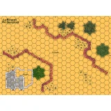
Herausgeber: Historic One
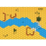
Cry Havoc Map The River
Map showing flat land cut through by a river that crosses at a ford. The map meets the Cry Havoc standard, is printed in high definition (300 dpi)...
Herausgeber: Historic One
Cry Havoc Map The Islet
Map of an ocean with a small island. The map meets the Cry Havoc standard, is printed in high definition (300 dpi) and on a strong varnished cardb...
Herausgeber: Historic One
Cry Havoc Map The Sheephold
Map representing a small pass guarded by a sheepfold. The map meets the Cry Havoc standard, is printed in high definition (300 dpi) and on a stron...
Herausgeber: Historic One
Cry Havoc Map The Woods
Map depicting a small forest. The map meets the Cry Havoc standard, is printed in high definition (300 dpi) and on a strong varnished cardboard si...
Herausgeber: Historic One
Cry Havoc Map The Saxon Harbour
Der FESTUNGSHAFEN besteht aus 4 Karten, die von Jean-Michel Clément entworfen wurden. Der Hafen selbst nimmt 2 Karten ein, mit seinem Lagerhaus und se...
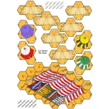
Herausgeber: Historic One
Cry Havoc Overlay The Tents
Overlays printed on A4 heavy paper featuring several tents and a larger one used by emirs. A component of the AGER SANGUINIS boxed set.